
Arquitectura de acoplamiento entre INS/GPS para navegación precisa en trayectorias establecidas
Barra lateral del artículo
Publicado:
2018-05-16
Palabras clave:
Sistema de Posicionamiento Global, Unidad de Medición Inercial, Sistema de Navegación Inercial, Arquitecturas de acoplamiento, Sensor, Filtro de Kalman, Filtro de Madgwick
Contenido principal del artículo
Resumen
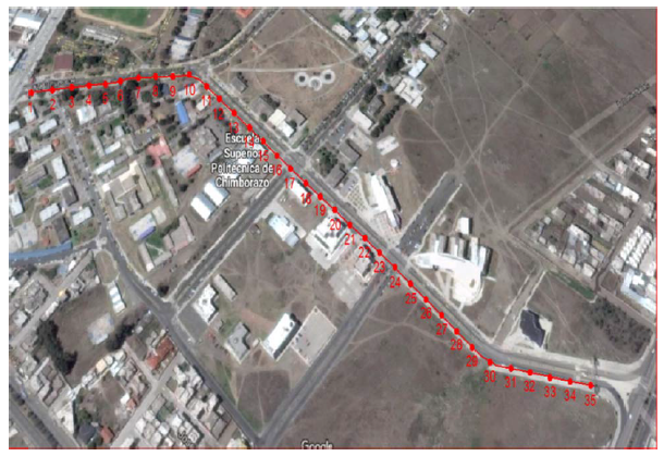
Se implementa un prototipo basado en tarjetas de desarrollo para el acoplamiento del sistema de navegación inercial con GPS para mejorar la precisión en la navegación sobre una trayectoria. Inicialmente es necesario la calibración de la unidad de medición inercial (IMU) mediante un filtro de MADGWICK para que los datos brutos extraídos sean fiables, el acoplamiento de las señales del sistema de posicionamiento global (GPS) e IMU se realiza a través de la arquitectura Tight Coupling por medio del Filtro de Kalman con el fin de eliminar errores correlacionados entre sistemas y alcanzar mejor precisión en la solución de navegación generalmente utilizada para aplicaciones en vehículos aéreos no tripulados (UAV). Se desarrolla la aplicación final denominada LJLAB en Matlab, cuya función es procesar y visualizar los datos medidos de ambos sistemas en forma independiente y acopladas al mostrar gráficamente el error en la precisión de posicionamiento que existe entre tecnologías, lo cual es comprobado estadísticamente a través del método experimental ANOVA que calcula el error absoluto entre los puntos reales y los medidos a través del análisis de la media y varianza de los datos observados.
##plugins.themes.bootstrap3.displayStats.downloads##
##plugins.themes.bootstrap3.displayStats.noStats##
Detalles del artículo
Número
Sección
ARTÍCULOS TÉCNICOS

Esta obra está bajo una licencia internacional Creative Commons Atribución 4.0.
Los autores que publican en esta revista están de acuerdo con los siguientes términos: Los autores conservan los derechos de autor y garantizan a la revista el derecho de ser la primera publicación del trabajo al igual que licenciado bajo una Creative Commons Attribution License que permite a otros compartir el trabajo con un reconocimiento de la autoría del trabajo y la publicación inicial en esta revista. Los autores pueden establecer por separado acuerdos adicionales para la distribución no exclusiva de la versión de la obra publicada en la revista (por ejemplo, situarlo en un repositorio institucional o publicarlo en un libro), con un reconocimiento de su publicación inicial en esta revista. Se permite y se anima a los autores a difundir sus trabajos electrónicamente (por ejemplo, en repositorios institucionales o en su propio sitio web) antes y durante el proceso de envío, ya que puede dar lugar a intercambios productivos, así como a una citación más temprana y mayor de los trabajos publicados.Cómo citar
Arquitectura de acoplamiento entre INS/GPS para navegación precisa en trayectorias establecidas. (2018). MASKAY, 8(1), 13-19. https://doi.org/10.24133/maskay.v8i1.590